 Overview
The MSc in Geospatial Engineering at IOE Pashchimanchal Campus, introduced in 2020 (2076 BS), is designed to address the growing demand for advanced geospatial expertise in Nepal. The program provides a comprehensive curriculum covering geographic information systems (GIS), remote sensing, spatial data analysis, Geodesy, Cadastre/administration, and geospatial technologies. The program addresses the increasing demand for professionals skilled in geospatial technologies, which play a critical role in various sectors such as infrastructure development, disaster management, environmental conservation, and sustainable urban planning. The launch of this program reflects Nepal growing recognition of the significance of geospatial science in tackling some of the country’s most pressing challenges.
Geospatial Engineering in Nepal Context
Nepal has a diverse topography, ranging from the lowland Terai plains to the towering Himalayan peaks, which presents unique opportunities and challenges. Managing natural resources, planning infrastructure projects, and responding to natural disasters in such a complex landscape require precise geospatial data and sophisticated analysis. The MSc in Geospatial Engineering at IOE Pashchimanchal Campus is designed to fill this gap by equipping students with the technical skills and theoretical knowledge to address the spatial dimensions of Nepal developmental challenges.
Given Nepal vulnerability to natural disasters, including earthquakes, landslides, floods, and glacial lake outburst floods (GLOFs), the ability to map, monitor, and predict such events is crucial. Geospatial technologies, such as Geographic Information Systems (GIS) and remote sensing, provide powerful tools for risk assessment and disaster preparedness. The MSc program, therefore, places a strong emphasis on the application of these tools in disaster risk management, enabling graduates to contribute to more resilient and informed development strategies in Nepal.
Practical Application and Research Opportunities
One of the program key strengths is its emphasis on practical application. Students are encouraged to apply the skills and knowledge gained in the classroom to real-world projects. This is facilitated through fieldwork, laboratory sessions, and internships with government agencies, private sector companies, and non-governmental organizations. These experiences not only help students develop practical skills but also provide them with valuable industry connections that can assist in their career development.
The MSc in Geospatial Engineering also emphasizes research, with students required to complete a thesis on a topic of their choice. This allows students to explore areas of personal or professional interest in depth, while also contributing to the body of knowledge in the geospatial field. Research topics typically focus on issues of national importance, such as disaster risk reduction, environmental management, and infrastructure planning, making the research highly relevant to Nepal development needs.
Career Prospects and National Impact
Graduates of the MSc in Geospatial Engineering program are well-positioned to take on leadership roles in a variety of sectors. Government agencies, international organizations, and private companies in Nepal are increasingly relying on geospatial technologies for decision-making, planning, and policy development. Graduates can pursue careers in urban planning, disaster management, environmental monitoring, land surveying, and infrastructure development, among other fields.
By producing highly skilled professionals in geospatial science, the program contributes to Nepal capacity to address its development challenges in a more informed, data-driven manner. Whether it is improving urban infrastructure, mitigating the impacts of climate change, or enhancing disaster preparedness, geospatial professionals will play an increasingly critical role in shaping the future of Nepal.
Program Structure and Curriculum
The MSc in Geospatial Engineering offers a comprehensive curriculum that covers key aspects of spatial data collection, analysis, and application. Core subjects include Geographic Information Systems (GIS), remote sensing, spatial data analysis, cartography, photogrammetry, geodesy, Research Methodology, Geodesy, GNSS, Cadastre, Land administration, Geospatial project organization and management, and programming for geospatial applications. These subjects provide students with a solid foundation in both the theoretical and practical aspects of geospatial science.
One of the program distinguishing features is its focus on advanced geospatial technologies, such as satellite-based remote sensing, LiDAR (Light Detection and Ranging), and Unmanned Aerial Vehicles (UAVs). These technologies are increasingly being used in Nepal for a range of applications, from mapping rural areas and monitoring natural resources to planning urban infrastructure and assessing climate change impacts. Through hands-on training, students gain expertise in operating these technologies, processing spatial data, and conducting spatial analyses.
The program also includes courses on programming languages, such as Python and R, which are essential for automating geospatial processes, developing geospatial models, and conducting spatial statistics. With the growing importance of data science and machine learning in the geospatial field, including these courses ensures that graduates are prepared for the rapidly evolving technological landscape.
In addition to core technical subjects, the program incorporates research methodology, GIS project management focuses on specialized areas such as urban planning, environmental monitoring, and land use/land cover change analysis. This interdisciplinary approach enables students to apply their geospatial expertise in a variety of fields, enhancing their versatility and employability.
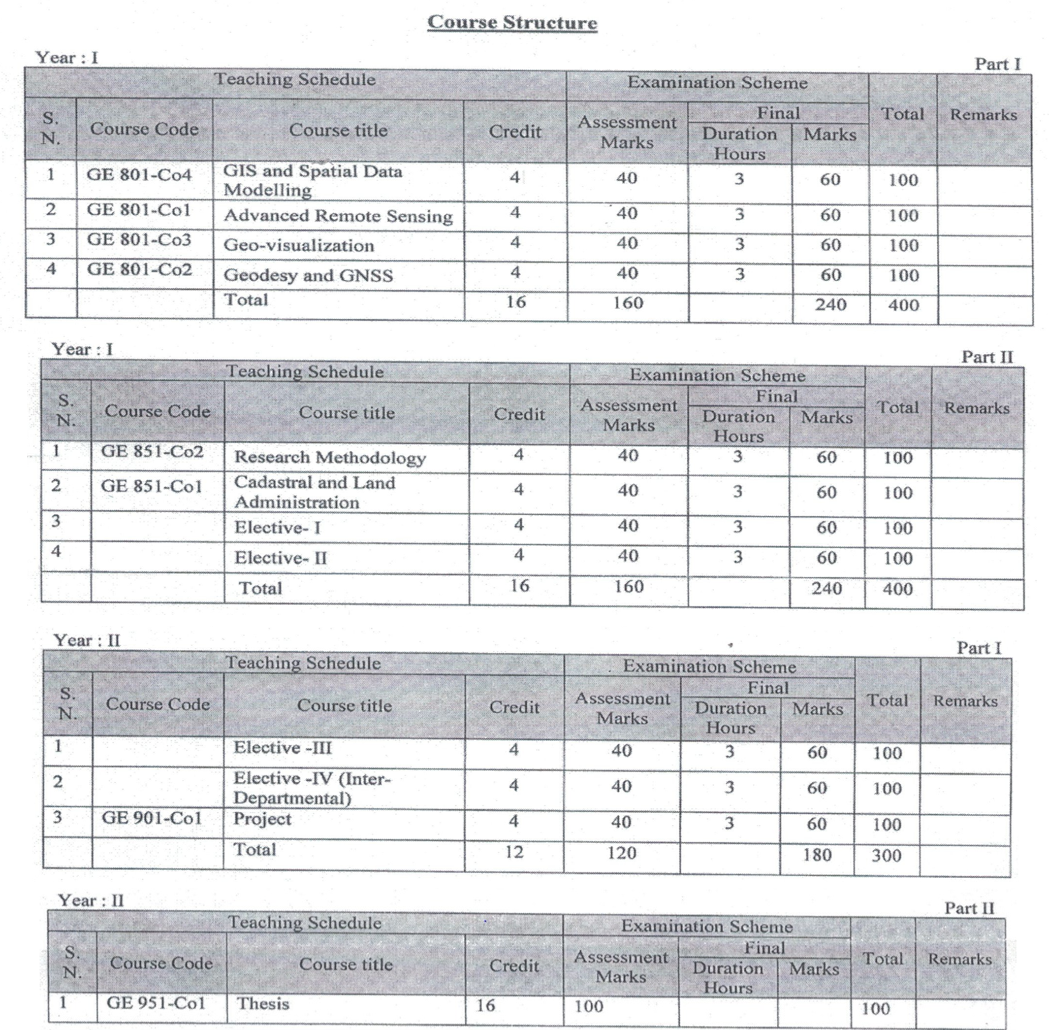
The program spans two academic years, divided into four semesters of six months each. It follows a credit-based system, with each course assigned a specific number of credits based on its duration and workload. The total requirement is 60 credits, consisting of 24 credits for core courses, 16 credits for electives, 4 credits for the project, and 16 credits for the thesis. Students can choose four elective courses according to their interests, with Elective I and II offered in the second semester, and Elective III and IV in the third semester. Each elective requires a minimum enrollment of six students. The distribution of courses for each semester is as follows:
Eligibility Criteria
To qualify for admission to the M.Sc. in Geospatial Engineering, candidates must have completed a 4-year B.E. in Geomatics Engineering, with undergraduate grades that are well above average and meet the minimum standards set by the IOE faculty board. Additionally, candidates must achieve the minimum score required by the IOE Faculty Board in the entrance examination administered by the IOE Entrance Board (or as recommended by a special entrance committee for foreign students).
Note: Equivalence refers to holding a comparable degree from institutions other than TU, recognized by TU as equivalent to the degree offered by TU in the same field.
Admission Criteria
Candidates interested in taking the entrance examination for enrollment in the M.Sc. program must submit the application form online within the deadline set by the Entrance Exam Board. The application forms are available on the websites: http://entrance.ioe.edu.np. The application process includes the following steps:
- Candidates must pay the required entrance exam application fee by depositing it into the account number specified in the notice, using a specially prepared voucher with the applicant’s name and date of birth. The voucher number should be included in the online application form.
- Candidates must select the correct entrance stream.
- All necessary fields in the application form should be filled without skipping any steps.
- Candidates must upload a color photo that meets the specified requirements, along with one of the following identification documents:
- Citizenship certificate
- Passport
- Last exam admit card
Summary
The MSc in Geospatial Engineering at IOE Pashchimanchal Campus is a vital academic program that aligns with Nepal national priorities. By equipping students with cutting-edge skills and knowledge in geospatial science, the program prepares them to tackle the complex challenges facing the country and contribute to its sustainable development.